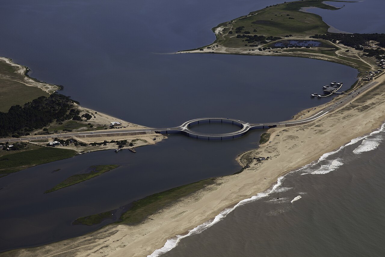
The Laguna Garzón Bridge is the circular bridge that links the departments of Maldonado and Rocha along Route 10, on Uruguay's Atlantic coast. Designed by Uruguayan architect Rafael Viñoly, it opened on December 22, 2015, replacing the raft that had carried cars across the lagoon since the mid-1990s. You can cross by car — each half of the ring carries one direction of traffic — or on foot, along the pedestrian walkway that runs the full perimeter.
This guide covers the bridge's history, why it is round, how to reach it from José Ignacio or Punta del Este, and what to know before walking across, taking photos and planning the rest of your day in the area. For background on the protected area surrounding the bridge, see The Lagoon.
From raft to bridge: the history
For about two decades, crossing Laguna Garzón along the coast meant waiting for the raft. From the mid-1990s until December 2015, Uruguay's National Directorate of Hydrography operated a small ferry raft that carried just a few cars per trip, with limited hours and queues that grew long in summer. In practice, the Rocha side of the coast was cut off from the José Ignacio and Punta del Este circuit.
The bridge changed that. According to the Ministry of Transport and Public Works (MTOP), the project, close to 12 million US dollars, was built under a public-private investment scheme: 80 % of the cost came from the company Las Garzas Blancas S.A., headed by Argentine businessman Eduardo Costantini, and the ministry put 1.8 million dollars into the connections between the bridge and Route 10. It opened on December 22, 2015, according to the Presidency, the raft making its last crossing the day before, on the 21st, according to Turismo Rocha. Since then it has been the permanent Route 10 connection between the two departments — and, along the way, a photographic icon of the Uruguayan coast.
Why is it round? Viñoly's design
The circular shape is no whim. Rafael Viñoly, a Uruguayan architect with an international career, conceived the bridge as a way to calm coastal traffic rather than speed it up: the curve forces cars to slow down, and the crossing becomes a promenade with open views over the lagoon and the ocean. At the same time, the light structure was meant to minimise the impact on a fragile ecosystem — Laguna Garzón is a protected area.
The structure's numbers, per the MTOP: a single-lane roundabout with diametrically opposed entry and exit, a central circular section of 51.5 metres radius and 323 metres length, two straight 46-metre approach sections, and a five-metre roadway between New Jersey barriers with cantilevered pedestrian walkways outside them. The ring rests on round concrete pillars; the portal found no official source that publishes how many. Vehicle traffic splits as it enters the ring: one half carries one direction, the other half the opposite, each with a single lane. Pedestrian walkways run along both sides of the roadway, with spots to sit and watch the water. At the centre, the ring frames a wide open circle of lagoon.
How to get to the bridge
The bridge sits on Route 10, at the border between Maldonado and Rocha, a few kilometres east of José Ignacio, which its own page places about 40 kilometres from Punta del Este. No official source publishes the bridge's exact kilometre: the last village addresses sit at km 185.5 and the first on the Rocha shore at km 190, as laid out in the kilometre-by-kilometre guide to Ruta 10. Coming from the west, follow Route 10 past La Juanita and José Ignacio: the bridge appears straight ahead, impossible to miss. Coming from the east, you reach it along the same Route 10 from the Rocha coast, or by turning off Route 9 onto the coastal access roads.
The most practical way to arrive is by car or a pre-arranged transfer; there is no urban bus stop at the bridge, so if you depend on public transport, check the interdepartmental services that run through the area and confirm where they stop. For parking, use the open areas and shoulders near the two bridge approaches — never on the roadway or on the ring itself. In January and February there can be a queue of cars waiting to enter; the rest of the year you cross without waiting.
Crossing on foot: photos, fishing and sunsets
Walking across is the best way to understand the bridge. The pedestrian walkway runs the full ring, so you can enter at one approach, walk the whole circle and come back: with photo stops, the stroll takes 15 to 30 minutes. From the point farthest from the shore, the view takes in the entire lagoon, the sandbar and the ocean beyond. You will often see people fishing from the perimeter, especially early in the morning and at dusk.
For photos, the best moments are sunrise and sunset, when low light paints the water and the concrete; the classic aerial shot of the full circle comes from drones and from the rises near the approaches. The other places to photograph in the area, with the right light and season for each, are in the photography guide to Laguna Garzón and José Ignacio. If you are here with the family, there is a dedicated note on sunset at the bridge with kids, with seasonal timings and tips. Bring a windproof layer even in summer: over the water there is almost always a breeze. And if your plan continues on the water, first check the rules for kayaks and boats on the lagoon — the protected area has its own regulations.
What to do around the bridge
The bridge is the gateway to a full day in the area. On the Rocha side the coast turns wild: long ocean beaches, dunes and the lagoon sandbar to walk along. On the Maldonado side you have José Ignacio, its lighthouse and its restaurants, a few minutes away by car. The lagoon itself is one of the area's best spots for birdwatching — black-necked swans, flamingos, herons — and for kayaking when conditions allow.
If you visit off-season, the plan changes but does not get worse: the guide to winter in José Ignacio and Laguna Garzón combines whales from the shore, birdlife and a winery visit in a single itinerary. And if you want to check on the bridge before travelling, the portal covers maintenance work on the bridge whenever it is officially announced.
Practical facts
- Location: Route 10, over Laguna Garzón, on the Maldonado–Rocha border
- Opened: December 22, 2015; replaced the Hydrography raft
- Design: Rafael Viñoly, Uruguayan architect
- Structure: Circular section of 51.5 m radius and 323 m length, straight 46 m approaches (MTOP); one-way traffic on each half of the ring
- Crossing on foot: Yes: walkways on both sides, full loop in 15–30 minutes
- Open: Year-round; maintenance closures are announced officially
- What to bring: Windproof jacket, water, camera or charged phone, binoculars for the birds
Frequently asked questions
Can you walk across the Laguna Garzón Bridge?
Yes. The bridge has pedestrian walkways on both sides of the roadway, and you can walk the full ring on foot. Crossing on foot is popular for taking in the lagoon from the centre of the circle, shooting photos or fishing from the perimeter. Park near the bridge approaches and bring a windproof layer: over the water it is almost always breezy.
Why is the Laguna Garzón Bridge circular?
The circular shape was a deliberate decision by architect Rafael Viñoly: it forces cars to slow down, turns the crossing into a scenic promenade with panoramic views, and reduces the structure's impact on the lagoon, which is a protected area. Traffic splits in two: each half of the ring carries a single one-way lane.
How long does it take to cross the bridge?
By car, the crossing takes about a minute, because the curve makes you drive slowly. On foot, walking the full ring with photo stops usually takes 15 to 30 minutes. In high season there can be a queue of cars waiting to enter the bridge; the rest of the year you cross without waiting.
Who designed the bridge and when did it open?
It was designed by Uruguayan architect Rafael Viñoly and opened on December 22, 2015. The project, close to 12 million US dollars, was a public-private investment: according to the MTOP, 80 % was financed by the company Las Garzas Blancas S.A., headed by Eduardo Costantini. It replaced the raft that had ferried cars across the lagoon since the mid-1990s.
Is the bridge open all year round?
Yes. The bridge connects Maldonado and Rocha along Route 10 all year, day and night. It only closes for occasional maintenance work, which is announced through the official channels of the departmental governments and the Ministry of Transport.
Sources: Ministry of Transport and Public Works, "Está habilitado al tránsito el puente sobre Laguna Garzón" (dimensions, public-private investment); Presidency of Uruguay, opening-day note (December 22, 2015); Turismo Rocha, Puente Laguna Garzón (raft 1995–2015); all three verified on September 20, 2026. Rafael Viñoly Architects (Laguna Garzón Bridge project page, no verified link); Portal Garzón (site news and listings). Update of September 20, 2026: structure and financing figures corrected per the MTOP; the pillar count was removed for lack of an official source.
Spotted an error? Write to hola@portalgarzon.com and we will fix it.